

You can find on this page the Atlanta topographic map to print and to download in PDF. The Atlanta elevation map present the topography, river and relief of Atlanta in Georgia - USA.
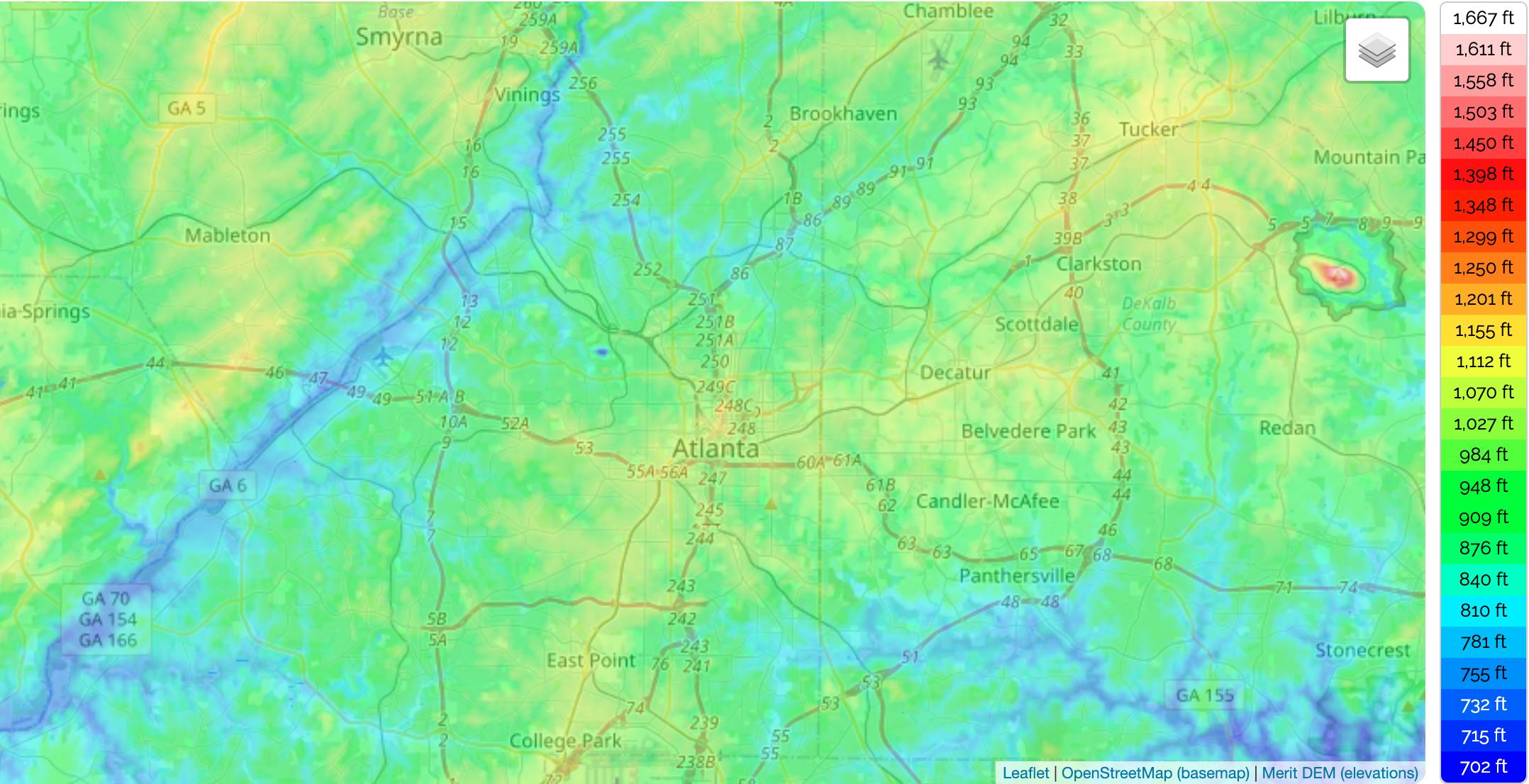
The Atlanta topographic map shows elevation, hills and landforms in Atlanta. This elevation map of Atlanta will allow you to know topography, river and relief of Atlanta in Georgia - USA. The Atlanta topographic map is downloadable in PDF, printable and free.
Located about 1,050 feet (320 m) above mean sea level as you can see in Atlanta elevation map, it sits atop a ridge south of the Chattahoochee River. Atlanta has the highest average elevation of any major city east of Denver. The Eastern Continental Divide line runs through Atlanta. Rainwater that falls on the south and east side runs eventually into the Atlantic Ocean, while rainwater on the north and west side of the divide ends up in the Gulf of Mexico via the Chattahoochee River. Being at the far northwestern edge of the city, much of the river natural habitat is still preserved, in part by the Chattahoochee River National Recreation Area. Downstream however, excessive water use during droughts and pollution during floods has been a source of contention and legal battles with neighboring states Alabama and Florida.
When considering the geographical statistics and location of any town or city, both in the United States and internationally, elevation is a very important term. Elevation tells us how high or low an area is in relation to sea level. The elevation of Atlanta is 1,050 feet (320 m), which means it has one of the highest elevations of any major city in Georgia and is actually one of the highest cities located to the east of the Mississippi. Various high points can be found in and around Atlanta. The highest point in the Atlanta metropolitan area is Kennesaw Mountain, which stands at an elevation of 1,808 feet (551 m) as its shown in Atlanta elevation map.
The mean elevation in the state of Georgia is 600 feet (180 m), which is also the same mean elevation as the states of Illinois and Maine, making Georgia one of the lowest states in America in general. When compared to the state average, the city of Atlanta has a relatively high elevation. Other major cities in Georgia apart from Atlanta include Augusta, which has an elevation of just 136 feet (45 m), Columbus, which has an elevation of 243 feet (74 m) and Macon, which has an elevation of 381 feet (116 m). Atlanta has a much higher elevation than these other major Georgia cities (see Atlanta elevation map).