

You can find on this page the Atlanta buses map to print and to download in PDF. The Atlanta bus system map and the Atlanta trolley map present the network, stations and lines of the buses and trolley of Atlanta in Georgia - USA.

The Atlanta bus map shows all the stations and lines of the Atlanta bus system. This bus map of Atlanta will allow you to easily plan your routes in the buses of Atlanta in Georgia - USA. The Atlanta bus system map is downloadable in PDF, printable and free.
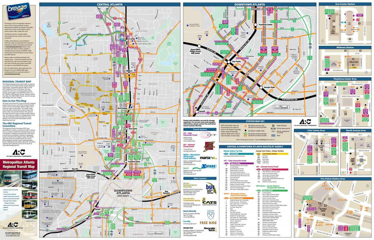
MARTA bus system serves a wider area than the rail system, serving areas in Fulton and DeKalb counties such as the cities of Roswell and Alpharetta in North Fulton, along with South DeKalb. As of 2010, MARTA has 554 diesel and compressed natural gas buses that cover over 91 bus routes which operated 25.9 million annual vehicle miles (41.7 million kilometers) as you can see in Atlanta bus map. Effective November 20, 2006, MARTA now has one bus route providing limited service in Cobb County (Route 12 has been extended to Cobb County Cumberland Boulevard Transfer Center). All of the MARTA bus lines feed into or intersect MARTA rail lines as well. MARTA shuttle service is available to Six Flags Over Georgia during the park summer season. In addition to the free parking adjacent to many rail stations, MARTA also operates five Park and ride lots serviced only by bus routes (Windward Parkway, Mansell Road, Stone Mountain, Barge Road, and South Fulton).
A 2001 federal civil lawsuit, Martin v. Metropolitan Atlanta Rapid Transit Authority, was brought by several disabled riders who alleged MARTA was violating the ADA by failing to provide: bus schedule and route information in an accessible format, buses with working wheelchair lifts, stop announcements on rail and bus routes, and adequate staff to schedule and provide on-time paratransit service. The district court ruled in 2002 that MARTA had violated the ADA and granted the plaintiffs an injunction requiring MARTA to improve service to the disabled. Currently the only active expansion in the entire MARTA system is the development of bus rapid transit along Memorial Drive from the former Avondale Mall to the MARTA park and ride lot in Stone Mountain as its shown in Atlanta bus map. (Bus Service started operating on September 27, 2010).
There are three other primary fixed-route bus providers in Atlanta: Georgia Regional Transportation Authority (GRTA) Xpress which offers commuter bus service in 12 counties in Metro Atlanta. All routes are connected with MARTA rail stations. CobbLinc which offers local bus service throughout Cobb County plus commuter bus service to Midtown and Downtown Atlanta as its mentioned in Atlanta bus map. Gwinnett County Transit (GCT) which offers local bus service within Gwinnett County plus commuter bus service to Downtown and Midtown Atlanta. A separate regional bus transit service, Xpress, is operated by the Georgia Regional Transportation Authority in partnership with 11 metro Atlanta counties including Fulton and DeKalb, which began service on June 6, 2004. The MARTA Board members are criticized for not being regular users of MARTA and thus are not actually aware of the concerns of MARTA commuters.